Citymapper, a dynamic urban mobility app, has emerged as an indispensable tool for city dwellers navigating complex transit systems. Launched in 2011, this innovative app has redefined the way people move within cities, offering a comprehensive and user-friendly platform that integrates various modes of transportation seamlessly.
At the core of Citymapper’s appeal is its ability to provide real-time, intelligent navigation solutions. The app covers a range of transportation options, including buses, trains, subways, bicycles, ride-sharing services, and walking routes. Users can input their destination, and Citymapper offers a variety of route options, considering current transit schedules, real-time delays, and disruptions. This ensures that users can make informed decisions about the fastest and most efficient way to reach their destination.
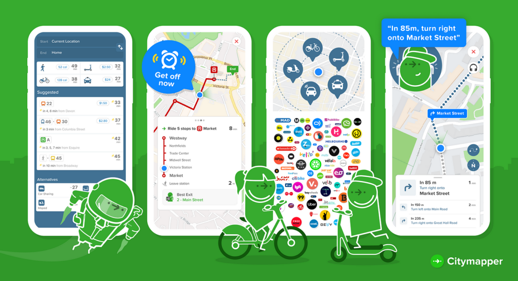
Citymapper’s user interface is designed with simplicity and functionality in mind. The app’s clean layout displays detailed route options, including step-by-step instructions, estimated travel times, and the cost of various transportation methods. Real-time updates keep users informed about any changes or delays during their journey.
Citymapper is known for its robust features that simplify urban navigation and enhance the commuting experience. Here are key features of the Citymapper app:
- Multimodal Routing: Citymapper provides comprehensive route options, integrating various transportation modes such as buses, trains, subways, walking, cycling, and ride-sharing services for seamless and efficient navigation.
- Real-Time Information: The app offers real-time updates on transit schedules, delays, and disruptions, ensuring users are informed about the current status of their chosen transportation options.
- Step-by-Step Directions: Citymapper provides detailed step-by-step directions, including the names of transit stops, transfer points, and walking directions to and from transit stations.
- Cost Estimation: Users can view the estimated cost of different transportation options, helping them make informed decisions based on budget considerations.
- Live Departure Times: Citymapper displays live departure times for public transportation services, allowing users to plan their journeys with accurate and up-to-date information.
- Offline Maps: The app offers offline maps, allowing users to access navigation information even when they don’t have an active internet connection.
- Journey Sharing: Users can share their planned routes or real-time locations with friends or family, enhancing safety and facilitating coordination.
- Nearby Transit Stops: Citymapper provides information about nearby transit stops, making it easy for users to find the most convenient access points.
- Bike-Share Integration: The app includes information on bike-sharing services, recommending bike routes and displaying the availability of bikes at nearby stations.
- Alerts and Notifications: Citymapper sends alerts and notifications about service disruptions, delays, or other relevant information that may affect the user’s journey.
- Accessibility Information: The app may include details about accessibility features at transit stations, making it helpful for users with specific mobility needs.
- City Expansion: Citymapper adapts to different cities globally, expanding its coverage to accommodate the specific transit systems and services available in each location.
- Dark Mode: The app may offer a dark mode option, providing a visually comfortable experience, especially in low-light conditions.
These features collectively position Citymapper as a comprehensive and user-centric urban navigation app, catering to the diverse needs of commuters in various cities around the world.